
WEST ALMOND TRAILS
RUN-WALK 2026

Saturday, August 29
IMPACT’s Signature Event—
bigger and better in year 2!
5k/10k Run/Walk plus 25k Run.

Thank You, Sponsors
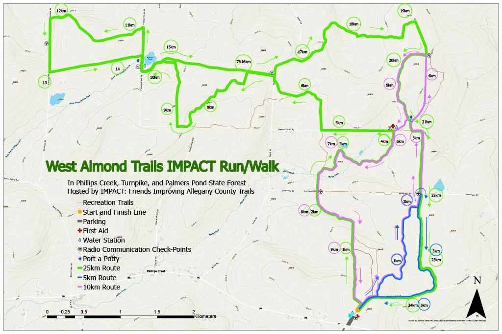
2026 Run-Walk Map
IMPACT: Friends Improving Allegany County Trails is hosting the second annual trail run through the forested Phillips Creek, Turnpike, and Palmers Pond State Forests.
NEW THIS YEAR is a 10K walk and a 25K race course for runners. Improvements to trail 3 were completed in 2025 and the 5K course has returned to the distance advertised. All courses pass through rolling hardwood stands as well as sections of older pine plantations showing off the beauty of Western New York. Map of Palmers Pond, Phillips Creek ,and Turnpike State Forest Trails:Map of State Forest Trails
-The 5K run and walk follows the the Trail 3 loop clockwise finishing at the trail head of the State Route 244 parking lot. The route is rolling and may have wet spots to cross. The longest climb of 25m comes at the 4km mark.
-The 10K run and walk follows the West side of Trail 3 then continues north on Trail 4 to the Stewart Forest Road. It then follows a short section of the gravel road north before turning onto the Trail 5 loop and heading back south to Trail 4, merging with Trail 6, and finally heading south on Trail 2/6 before finishing at the trailhead of the State Route 244 parking lot. There is one creek crossing and potential for mud or wet spots to run/walk through. The topography varies greatly with many small hills while the overall elevation change along the 10K route results in a ~60m loss over the first 7.5 kilometers, which it gains back over the last 2.5 kilometers. The route is similar to last year when it was well received and considered a scenic and exciting challenge for trail racers. We hope it will be equally enjoyable and invigorating for walkers.
The newly added 25K run follows both well traveled and little traveled trails along with some gravel and seasonal roads to connect trails of all three state forests. There are creek crossings and high potential for mud and wet spots to run through. Additionally, the topography varies greatly with many small hills and several larger ones making this a scenic, exciting and challenging 25K trail,